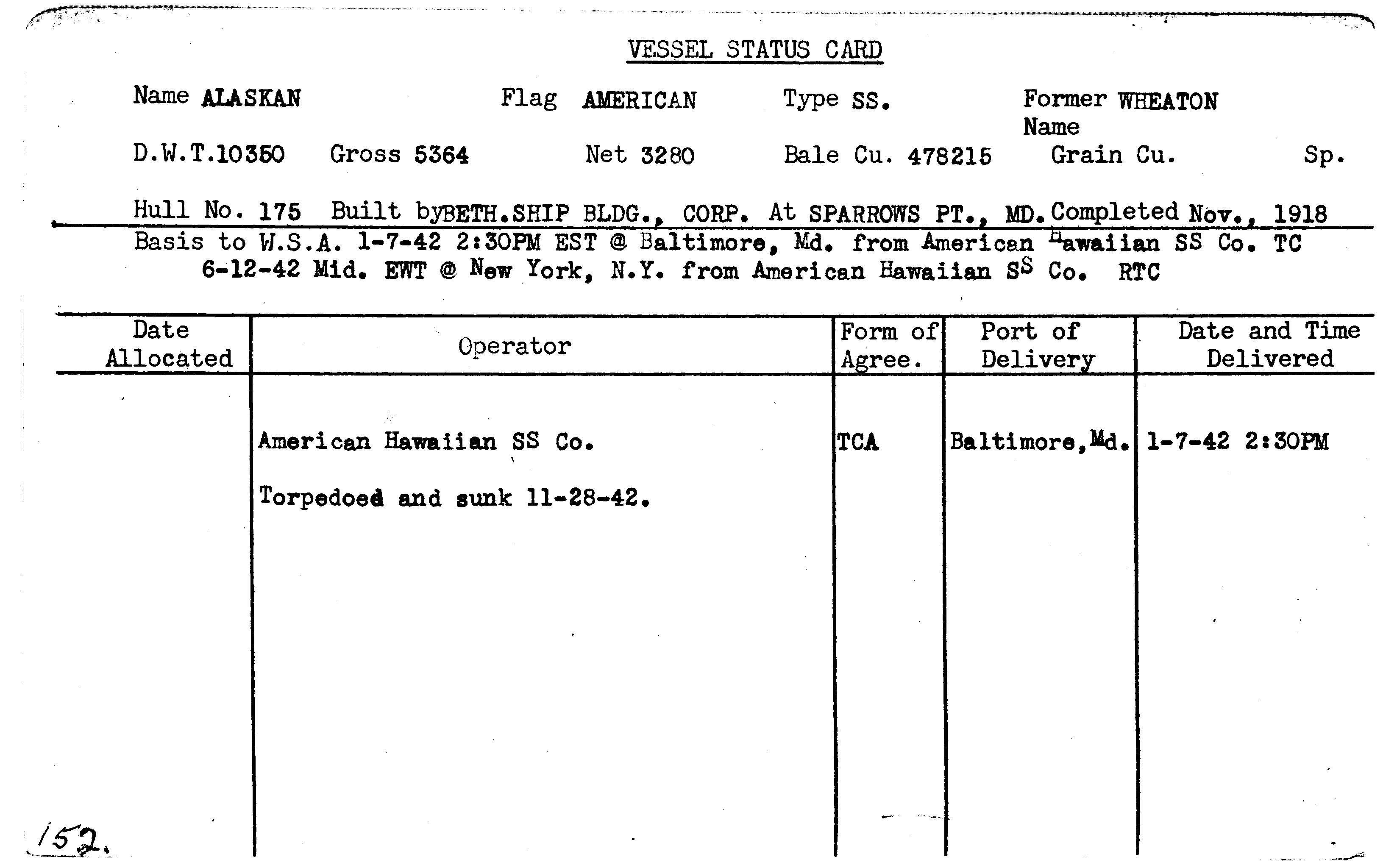
ALASKAN

Year Built
1918
Official Number
217232
Shipyard
Bethlehem-Sparrows Point Shipyard
General Type
General Cargo
Specific Type
Combination Refrigerated
MARAD Type
Private
Ship Length
414.00 feet
Beam
54.00 feet
Mast Height
--
Net Tons
3280.00 tons
Gross Tons
5364.00 tons
Cargo Capacity
478215.00 square feet
Draft, Summer
--
Draft, Lightweight
--
Displacement, Summer
--
Displacement, Lightweight
--
Immersion, Summer
--
Immersion, Lightweight
--
Fate
Sunk - Torpedo
Historical Narrative
There is no historical narrative for this vessel at this time.
Vessel Name History
Mission
| Mission Name |
|---|
| World War II |
Historical Documents
| Name | Download |
|---|---|
| SYSTEM UPLOAD |
|
| SYSTEM UPLOAD |
|
| SYSTEM UPLOAD |
|
| SYSTEM UPLOAD |
|
| SYSTEM UPLOAD |
|
Milestones
| Event | Date | Content |
|---|---|---|
|
Sunk
| 11/28/1942 | Torpedoed and shelled by German submarine U-172 while en-route from Cape Town to Paramarido, Dutch Guiana |
Ship Imagery
No images for this vessel
Status Cards
Documents
| Date | Type | Name | Download | |
|---|---|---|---|---|
| (No Date) | ALASKAN.pdf |
|
||
| (No Date) | Historical | SYSTEM UPLOAD |
|
|
| (No Date) | Historical | SYSTEM UPLOAD |
|
|
| (No Date) | Historical | SYSTEM UPLOAD |
|
|
| (No Date) | Historical | SYSTEM UPLOAD |
|
|
| (No Date) | Historical | SYSTEM UPLOAD |
|
Plans
No documents for this vessel
Shipwreck Information
Vessel Information
Owner
War Shipping Administration
Operator
American-Hawaiian Steamship Company
Operator Agreement
Time Charter Agreement
Flag State
United States
Incident Information
Incident Date
November 28, 1942
Use at Loss
Cargo Transportation
Cause
Sunk - Torpedo
Cause Comments
Torpedoed and shelled by German submarine U-172 while en route from Cape Town, South Africa, to Paramaribo, Dutch Guiana (Suriname), and a U.S. port.
Conflict
World War II
Location of Incident
Atlantic Ocean
Accuracy of Incident Location
Historic 1
Lat/Long
02° 38' N., 28° 58' W.
Incident Location Comments
Northeast of St. Paul's Rocks, about 800 miles northeast of Natal, Brazil
Lives Lost
--

